
Ayton in history
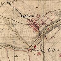
Aytoun map
Ayton – the name ‘place on the river eye’ river name éa (Old English) ‘running stream’ with –tun (OE) ‘farmstead’; it was recorded as Eitun 1098. On the left is an extract from Roy’s Military survey of Scotland, produced between 1747-1755 in the wake of the Jacobite rebellion.
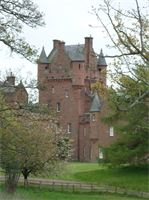
Ayton Castle. photo Andrew Dutton
James Gillespie Graham’s grand 19th century Scots Baronial design. Ayton Castle was once the principal seat of the feudal barony of Ayton. The present castle, a grand example of Scots Baronial architecture, dates largely from the mid 19th century. An earlier castle, or tower house on the site was once the stronghold of the Home family and was captured by the English in 1497. The nearby 11th century church of St Dionysius was the scene of the subsequent negotiation of the treaty of Ayton, signed on 30 September 1497. Formal gardens or policies around the homes of the wealthy became popular during the 18th century; Roy’s map of Ayton appears to show evidence of a designed landscape around the site of the earlier castle, which was destroyed by fire in 1834.
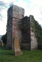
St Dionysius. photo Andrew Dutton
The lands of Eitun were granted to the priory of Coldingham by King Edgar between 1098 and 1107 and before the close of the 12th century the monks erected a chapel here dedicated to St Dionysius (St Denis, also patron saint of France). This was used as a meeting place by Scottish and English Commissioners to negotiate treaties between the two kingdoms in 1380, 1384 and 1497. The chapel became the parish church after the Reformation, perhaps in 1627. The church was extensively altered and rebuilt in the 17th and 18th centuries when many of the original Norman features were removed or altered and it is difficult now to make out the form of the original structure but is well worth a visit. The present parish church stands close by and was built in 1865. This information is partly derived from www.scottishbordersheritage.co.uk